To many people, hurricanes are the most interesting weather events that
occur in Louisiana. Twenty-four named and 46 unnamed tropical systems
affected the State between 1886 and 1992. Based on these numbers, the
State on average experiences approximately three systems of at least tropical
depression strength over a two-year period. Perhaps the most recent
hurricane of note is Andrew, which came ashore as a Category
3 hurricane having winds of 115 mph on 26 August 1992.
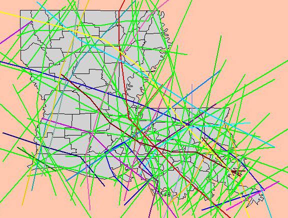
The tracks of all tropical depressions, tropical storms, and hurricanes that have affected Louisiana between 1886 and 1992 have been plotted on a state map based on data from the National Hurricane Center. These paths can be viewed using ESRI's Internet Map Server (IMS) running at ULM. For a brief description of how to use the tools in IMS, click here.
To view the map of storm tracks, click
here or on the image below.
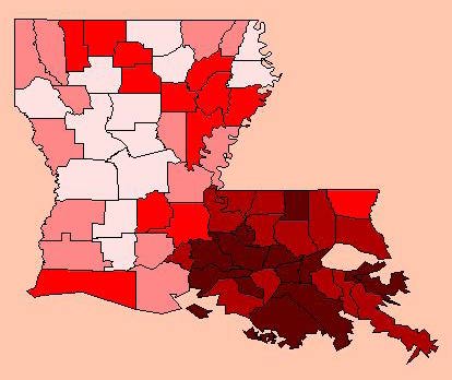
As might be expected, the distribution of tropical systems across the state shows a greater frequency in the southern parishes (darker colors below indicate greater frequencies). LaFourche Parish experienced more tropical systems than any other region, averaging between 12 and 13 systems per 20 year period per 1000 sq. miles. The fewest tropical systems crossed DeSoto Parish, where the frequency of tropical systems averaged approximately 1 per 50 years per 1000 sq. miles. To view of map of the parish-by-parish frequency for tropical systems, click here or on the image below.